VKA completes ultra high resolution drone image survey on US tungsten asset
Our US tungsten Investment Viking Mines (ASX: VKA) just completed an aerial drone survey at its US tungsten project.
VKA announced its move into US tungsten back in December which is when we Invested in VKA.
Check out our full initiation note here: Our Latest Investment: Viking Mines (ASX: VKA)
Today, VKA has completed the ultra-high-resolution orthomosaic drone survey at its Linka Tungsten Project in Nevada, USA.
This survey has provided a highly detailed 2cm pixel resolution imagery and a detailed Digital Elevation Model (DEM).
The new data will be used to confirm and validate historic data and has given the company a much higher quality aerial view across the entire project area.
One of the key goals of the survey was to identify five historical survey points from the 1970s which has been successfully completed.
Now VKA will integrate this with its recently acquired 50 year old paper records into modern 3D geological modeling software, resulting in a high resolution "Digital Twin" of the project area.
These paper records VKA mentioned today have an estimated value of ~$1M due to the drilling and associated works that would be required to have done this exploration from scratch.
The images also show visual confirmation of outcropping tungsten mineralisation and historical infrastructure on the project such as shafts and prior drillhole locations.
VKA also made a comment that it may be able to make estimates on the size of the stockpiles based around these images announced today.
So these images will aid VKA in its future planning on project works (e.g. drilling) as it will be able to scope out and plan knowing the best access routes and terrain without needing to be on the project.
The images taken also revealed things such as access roads and will aid the company to minimise its environmental impacts which could lead to a reduced environmental drilling bond payments.
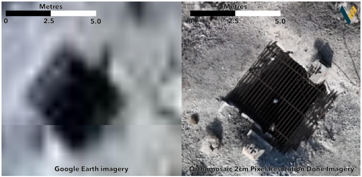
VKA included an example of the imagery which is clearly a massive upgrade from using google earth imagery:
(source)
With today’s news, VKA will be aiming to make some progress on the following in the near term as it goes about creating the digital model and integrating all of the new images and old historical data amongst other progress:
- Digitisation of historical data for 3D geological modeling and drill targeting
- Planning for a ground gravity and magnetics survey to identify additional drill targets
- Finalising drill targets for Notice of Intent (NOI) submission to Federal Agencies
- Continuing technical evaluation of five additional tungsten projects in their portfolio
We did a deep dive article on VKA last week that included some recent updates which you can catch up on here, including the exploration data that was acquired: Tungsten at all time highs. VKA acquires historical tungsten drill data for its ground - saving months of work and exploration spend.
What do we want to see VKA do next?
🔄Complete the acquisition of the new tungsten assets.
Next, we want to see VKA complete the acquisition of its six tungsten assets in the US.
VKA set the notice of meeting to have the deal approved for 12th of February, so we should see that news soon.
🔄Early metwork testing
VKA recently sent off a bulk sample to test its viability for processing.
In particular there is a focus on exploring the viability for this to be used in an early production opportunity scenario, with results from this expected in February. (source)
🔄 Target generation work (mapping/sampling)
We want to see VKA complete rounds of sampling (including channel/rock chip sampling) to confirm historic tungsten mineralisation at the project.
We also want to see the project mapped with LiDAR to reveal the full extent of the underground workings on the project.
Milestones:
🔄 Mapping and sampling (soils and rock chips)
🔲 Geophysics/LiDAR
🔲 Drill targets confirmed